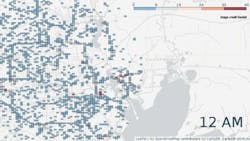
Interactive map shows impact of Hurricane Harvey on commercial traffic in Houston TX
Telematics company Geotab has launched an interactive map showing the dramatic reduction in commercial fleet activity in Houston TX in the wake of Hurricane/Tropical Storm Harvey. The storm brought disastrous flooding that caused closures on major roads, frontage lanes, and exits during what is likely to become the costliest natural disaster in US history.
Geotab, a global leader in smart transportation and telematics technology, launched a time-lapse map, which will be updated weekly, to track commercial fleet activity in Houston and surrounding cities.
The time-lapse map by Geotab illustrates the impact of Hurricane Harvey by showing the drastic reduction in vehicles in the affected areas. Based on data provided by Geotab, there has been an 88% reduction in commercial fleet activity in the Houston area in one week, from August 21 to August 28--translating into severe economic losses and downtime. Geotab will be providing weekly updates to the interactive map during this time of crisis.
“There are Geotab devices in approximately 52,000 vehicles in Texas, including 8,000 vehicles in the Houston area,” said Neil Cawse, chief executive officer, Geotab. “It is crucial that we do everything possible to help our customers protect the lives and safety of their drivers in the affected areas as we continue to face the outcome of this storm. Geotab is working closely with our partners to provide relevant data so that commercial and emergency fleets are able to travel safely and respond urgently to the victims of Hurricane Harvey.”
According to the Texas Department of Transportation (TxDOT) over 500 roadways in southeast Texas are currently experiencing flood conditions. However, flood waters have receded significantly in many parts of the Greater Houston over the past day or so.
Businesses using a telematics system with Geotab devices can stay in touch with commercial drivers and access real-time updates allowing them to stay in constant communication and let them know if they need to take appropriate detours or make complete stops.
Visit www.geotab.com/blog/hurricane-harvey-telematics-data-timelapse/ for weekly interactive map updates during this time of crisis.
